Serviços Topográficos de Alta Qualidade

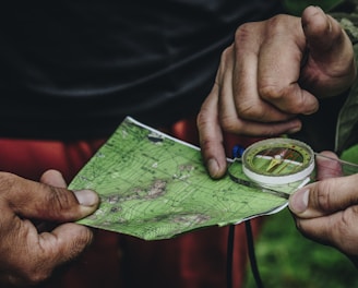
Construindo o futuro com precisão.

Levantamento planialtimétrico com precisão e eficiência.

Demarcação de terrenos com tecnologia de ponta.

Regularização fundiária com atendimento personalizado.

A surveyor's tripod with a total station is set up on a grassy hill overlooking a sprawling rural area with fields and industrial buildings. The sky is overcast, slightly obscuring the distant horizon, and there is a utility bag on the ground nearby.
A close-up of a surveying instrument, specifically a total station, mounted on a tripod. The instrument features an orange cylindrical target with a reflective surface and a black and yellow square backing with a cross pattern. The background is blurred, showing some cars and trees, suggesting an outdoor setting.
A tripod-mounted surveying instrument is prominently placed in the foreground, with a large construction site visible in the background. Tall cranes and unfinished buildings indicate ongoing construction work, set against a clear blue sky.

Precisão e qualidade em topografia

Na IG Topografia, transformamos precisão em resultados. Oferecemos serviços topográficos de alta qualidade, garantindo excelência e atendimento personalizado para o sucesso do seu projeto.

A surveying instrument mounted on a tall pole stands in the foreground, with a bright blue sky and scattered clouds above. In the background, there are several modern high-rise buildings, indicating an urban area.
Compromisso com a excelência
Soluções topográficas especializadas

Combinamos tecnologia de ponta e experiência de campo para fornecer detalhes essenciais, atendendo projetos de engenharia, construção civil e regularização fundiária com seriedade e profissionalismo.

Serviços Topográficos

Precisão e qualidade em serviços topográficos para o sucesso do seu projeto.

Levantamento Planialtimétrico

Realizamos levantamentos precisos para garantir a base sólida do seu projeto de engenharia.

A metal topographical indicator displaying various landmarks, distances, and heights is prominently in focus. The background reveals an out-of-focus rocky terrain and a blurred figure of a person, suggesting an outdoor, elevated setting.
Demarcação de Terrenos

Oferecemos serviços de demarcação de terrenos com total precisão e profissionalismo para sua segurança.

A person wearing a white hard hat and high-visibility vest operates a surveying instrument, focusing intently on the task at hand. The background is blurred with hints of other construction activities or team members.

Projetos Topográficos

Oferecemos serviços precisos para garantir o sucesso do seu projeto.

Hands are holding a topographic map and a compass. One hand is pointing at a specific location on the map, indicating navigation or orientation. The map is detailed with green shades, representing terrain or elevation.
Levantamento Planialtimétrico

Realizamos levantamentos planialtimétricos com tecnologia de ponta para atender suas necessidades específicas, assegurando a precisão necessária para o desenvolvimento de projetos de engenharia e construção civil.

Three men are working on a green field; one is operating a theodolite on a tripod, while the other two are kneeling on the grass, marking or measuring points. In the background, a small airplane is parked in front of a hangar, which has bold numbers painted on its roof. The sky is partly cloudy, and there is a tall communications or weather tower near the hangar.
Demarcação de Terrenos

Nossa equipe especializada realiza demarcações de terrenos com seriedade e profissionalismo, garantindo a segurança e a conformidade legal para o seu projeto de regularização fundiária.

Avaliações Clientes

Veja o que nossos clientes dizem sobre nossos serviços topográficos.

Ótimo profissional, dedicado, prestativo e não mede esforços nas entregas dos trabalhos, recomendo.

Jose Gustavo

Ótimo profissional, solicitei um serviço e ele realizou o com qualidade e eficiência. Voltarei a contratar se eu precisar

Rafael Oliveira

★★★★★
★★★★★